

We have a good friend, Ken F., who has two big-time interests, sports and the Civil War. Ken and my husband talk for hours about sports, and Ken and I enjoy sharing CW books and discussions. Ken and his equally interesting wife, Eileen, recently made another trek to two of the most iconic CW battlefields in the East, Antietam, in Maryland, and Gettysburg, in Pennsylvania. One of his goals on such visits is to locate battle site views that still resemble today, as closely as possible, the incredible images that were captured by the great CW photographers in the 1860’s, minus the heartbreaking carnage, of course! He recently agreed to be a guest photographer here on You’re History (thanks, Ken!), and it’s my pleasure to share his great photos and commentary with you.
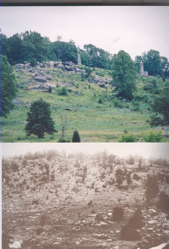
Gettysburg: Little Round Top
“Then” photo by Timothy O’Sullivan.
Troops along the ridge line and slopes were the left wing of the Union, coming under attack from the Confederate right wing under Gen. James Longstreet, who were never able to capture this high ground. The area at the base of Little Round Top was know as “The Valley of Death”, as it was almost certain death crossing that area. This view is looking east. The famous stand of the Union 20th. Maine occured at the far right, upon the south slope of the hill. Most of the fighting in this area happened during the second day of the three day conflict, July 3, 1863.
All three of the “then” Antietam photos below were taken by Alexander Gardner. Battle took place September 17, 1862.
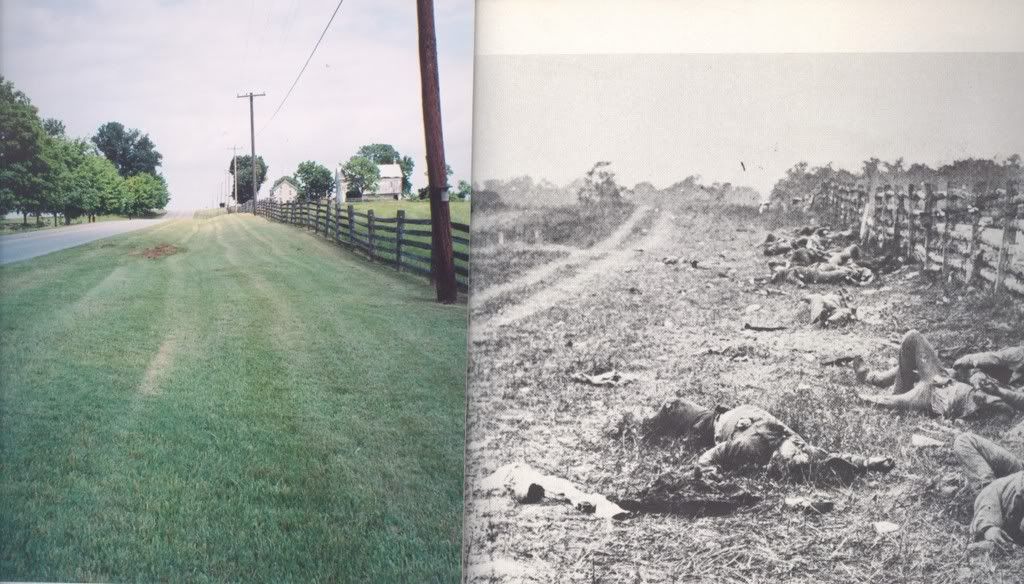
Antietam: Hagerstown Pike
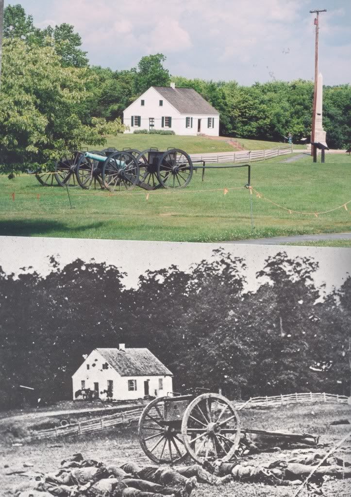
Antietam: Dunker Church
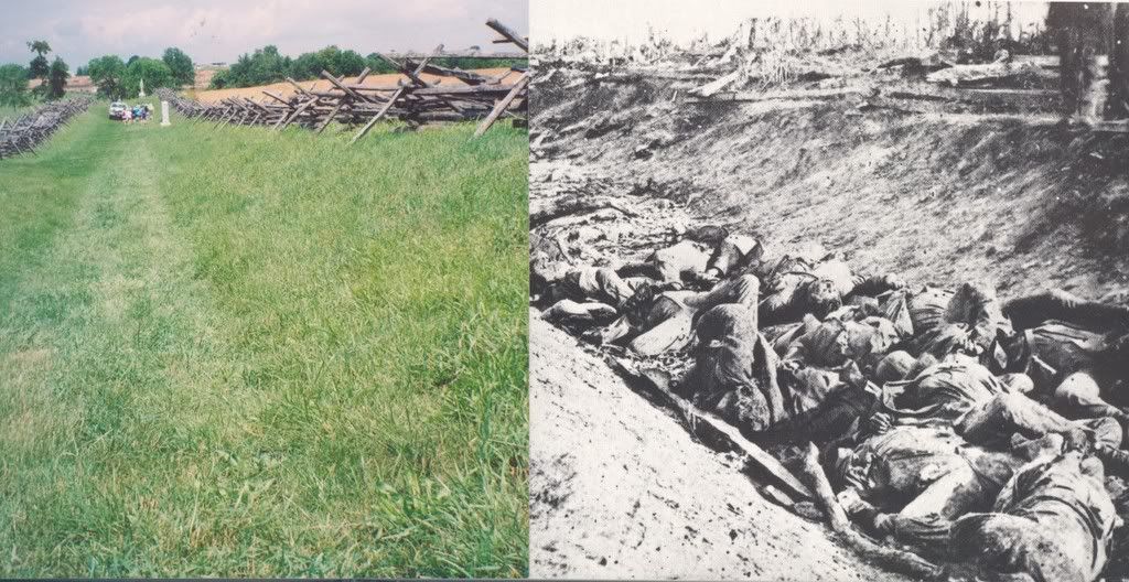
Antietam: The Sunken road

Oh those pictures were just wonderful! Just looking at the Antietam pix you could almost imagine the war just happened, it’s kind of like you stepped through time
Reiterating what I already told Linda, I found these pictures very moving, and felt, as historylover does, as though I had been there originally. I’m here in Utah, thinking of a war that never touched this spot. Thank you.
What a cool post! I live in Vicksburg, Mississippi, and am working at trying to learn more about the Civil War. There’s so much I don’t know! And, we’re surrounded by history, here. There’s an antebellum mansion that still has a cannonball lodged in the wall, in downtown Vicksburg.
I’m from OZ.It’s eerie looking at these old photo’s. I love Your History;the now and then site. Will be over there soon and have a look at it all for ourselves. Don’t take your history for granted. See ya.
Man, great pictures. Where can I see more like these ? Thank you so much
I believe the Hagerstown Pike “now” image is looking north, while the historic image is looking south — inside the fence, with the Miller cornfield behind the photographer. The confusion comes from the trail visible at the left of the historic images, which is not the Hagerstown Pike — it’s a trail inside the fence line. The pike is to the right of the historic image, on the other side of the rail fence. It’s clearer here:
I’ve been trying to figure this out and agree with you. What I was missing is that the historic image is looking south. Now, if I could just figure out where the roadbed was for the Hagerstown Pike in 1862, I would love to take my own now photo of the exact spot where then bodies were. Surely the road is wider now and has swallowed up the old roadbed. Where is it? Oh, yeah. This past Saturday I took one exactly like what’s shown here! Ha!
You see Antietam: The Sunken road me and my mom walked along that road.It is amazing.
Actually, most say the Confederate dead were on the west side of the Hagerstown Pike. So the Gardner must have been facing north. What do you think?
The photographer was facing north, on the west side of the pike. The tracks on the left of the original photo are a farm road.
See William Frassanito’s excellent book “Antietam”. He documents the original locations of nearly all the Gardner photos taken shortly after the battle.
My 84 year old stepdad and I visited this site just today. I had been there once before. It is puzzling how I could be attracted to the beauty and serenity of this battlefield knowing what occured there. But it calls to me and I will probably go back yet again.
Wanda, I think there’s something transcendental about all these sites where such sacrifices were made. I know how you feel. Thanks for your comment.
In the Sunken Road photo, if the dead are North Carolinians, they would be from G.B. Anderson’s brigade which was part of D.H. Hill’s division in Jackson’s Corps. They held the road most of the morning. If these men are from R.H. Anderson’s division they would be Georgians from Wright’s brigade who reinforced the far right of the NC troops shortly before the position fell. The modern photo appears to be positioned from the far right of the Confederate line looking back toward the shallow angle in the road that roughly marked the middle of the Confederate line.
Very fine work. Anyone interested in ‘before and after’ sites from the pages of the James E. Taylor Sketchbook? 1864 Shenandoah Valley Campaign from August thru December.
Dane, would love to see them.
Thanks for visiting and commenting.